Public Meeting
Hamestring Tributary Restoration
through Red Oak Park
5:30 PM Thursday, November 19, 2009
Public Meeting Handout.11-19-09 Page 1 of 3
I. Existing Conditions and Explanation of Problem:
• The approximately 100-acre watershed that is draining through Red Oak Park COMPRISES
mostly 1⁄4-acre residential lots. Predevelopment land use was undeveloped pasture.
Undeveloped pasture 20% to 30% storm water runoff
Residential development 60% to 75% storm water runoff
• The average storm water velocity within the park area and the downstream property computed
by the City Engineering staff in 2004 was approximately 10 feet per second.
• The soils (cherty silt loam) are highly susceptible to erosion and the stream will likely continue to
erode due to the geology of the adjacent soils, the volume of storm water and the resulting high
velocities. However, survey data obtained in 2009 shows minimal changes in the stream
channel when compared to the data collected in 2004 which may indicate that the erosion is
stabilizing somewhat.
• Several mature trees that are in close proximity to the channel are in danger of falling due to the
erosion within the root systems. Approximately 15 trees were removed within the park after the
January 2009 ice storm.
• The railroad ties in the upstream portion of the channel are washing downstream.
• Severe erosion has occurred around the gabion structures located in the northern area of the
park. The Parks and Recreation staff has removed one gabion structure to alleviate flooding and
erosion.
• Severe erosion is also occurring on the property downstream from the park. The downstream
property owner removed approx. 35 dump truck loads of gravel from a manmade dam area in
2002. The same level of sedimentation returned in less than two years.
II. Where Have We Been?
1986 Aerial photographs show the immediate area around what is now Red Oak Park as wooded.
The aerial shows the land use from Wedington Drive north to Hamestring Creek and from 51st
Avenue east to Rupple Road was undeveloped. A small subdivision existed just north of
Wedington Drive, and a few chicken houses were scattered throughout this area.
2004 A drainage study was performed by the City Engineering staff. Recommendations included 400
feet of 60” diameter storm pipe and 600 feet of creek stabilization using native stone boulders,
compacted hillside material and colored concrete on the section south of New Bridge Road. On
the section north of New Bridge Road, 275 feet of 66” diameter storm pipe with a small grass-
lined swale was recommended.
2007 Mr. Dave Evans, Region 1 Stream Team Coordinator of the Arkansas Game and Fish
Commission (AGFC), provided another design to attempt to resolve the erosion problems that
exist in the stream that bisects the park. A permit for this design was obtained from the U.S.
Army Corps of Engineers (USACE). Proposed project included:
♦ Removal of the existing concrete, railroad ties and gabion structures;
♦ Significant tree removal (approximately 55 to 70 trees);
♦ Modification of the existing channel to create a larger area to handle runoff events which
included shaping one or both banks to increase the total channel area;
♦ Construction of approximately 20 pairs and 14 individual rock plunge pools within the newly
shaped channel; and
♦ Tree and shrub planting plan to establish vegetation.
Parks and Engineering staff began to reconsider the natural stream channel approach after the
stream restoration project was completed at Gulley Park.
Public Meeting
Hamestring Tributary Restoration
through Red Oak Park
5:30 PM Thursday, November 19, 2009
Public Meeting Handout.11-19-09 Page 2 of 3
II. Where Have We Been? (continued)
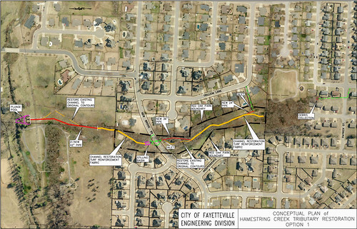
2009 Additional drainage calculations and analyses were performed by the City Engineering staff.
Recommendations include two options as shown in the drawings and as described below:
Table 1. Comparison of Design Options
Description Pros Cons Cost Estimates*
Option 1
Debris collection at south end of
park; channel restoration thru
park; one 24” dia. pipe and one
36” dia. pipe in park; stilling
basin on north end of park; two
42” dia. pipes and plunge pool
on adjacent property north of
park.
Design will resolve the
erosion problems in the
park
Will allow for some
reclamation of park land
near New Bridge Road
Significantly less tree
removal within park than
AGFC design
More expensive than
Option 2
Will not provide
significant infiltration
of storm water
In Red Oak Park -
$320,000
Downstream -
$170,000
Total $490,000
Option 2
Control structure with debris
collection in park south of New
Bridge Road; removal of
existing park pavilion; no
channel restoration thru park; no
pipes in park; stilling basin on
north end of park; two 42” dia.
pipes and plunge pool on
adjacent property north of park.
Will allow for some
infiltration of storm water
in the park south of New
Bridge Road
Basically no tree
removal within park
Less expensive than
Option 1 allowing for
park funds to be utilized
at Bryce Davis Park
(new Community Park
under design) or at the
southernmost 2.25 acres
of Red Oak Park
Design will not
resolve the erosion
problems in the park
Existing park will be
reclassified and used
only as a natural
greenway area
In Red Oak Park -
$65,000
Downstream -
$150,000
Total $215,000
* Cost Estimates include construction by outside contractor(s)
III. Funding Items:
• This project is funded with Sales Tax funds. The cost estimates shown in Table 1 above include
construction by outside contractor(s). Cost estimates of materials only for each option are:
Option 1 (Materials Only): In Red Oak Park-$166,000; downstream $96,000 Total $262,000
Option 2 (Materials Only): In Red Oak Park-$35,000; downstream $85,000 Total $120,000
• Earlier plan included partnering with the Arkansas Game and Fish Commission. The cost
estimate for Materials Only was $99,530. The project was financially viable because of the
assistance of AGFC staff (at no cost to the City) and the use of City staff and equipment for tree
removal, excavation, placement of stone and revegetation with grass. The use of volunteers for
the planting of the shrubs and trees also kept the project cost low.
Public Meeting
Hamestring Tributary Restoration
through Red Oak Park
5:30 PM Thursday, November 19, 2009
Public Meeting Handout.11-19-09 Page 3 of 3
IV. Where Are We Going?
• Storm water detention in the upper area of the watershed is most likely not possible due to the
development. Engineers from the local USDA offices performed a preliminary assessment of the
site to determine the size of detention basin that would be required to contain the flow. Their
preliminary assessment concluded that there is not enough area available for detention.
Additionally. City Engineering Staff confirmed that detention is not an option without significant
tree removal and earthwork (i.e., removal of all trees and several feet of excavation of the entire
park area).
• The use of rain gardens is not likely feasible due to the fact that the City cannot require
residents to install and maintain the gardens on their properties. Additionally, a comprehensive
study must be performed to determine the best placement of rain gardens, etc. The bulk of the
storm water flow into the channel that runs through Red Oak Park is coming from the streets
and underground piping associated with the surrounding subdivisions. In addition, rain gardens
are typically designed for two-year or smaller rain events, and larger storm event flows and
velocities are not affected by rain gardens.
• Any work in the channel requires a Section 404 permit from the U.S. Army Corps of Engineers
(USACE), and any new or different design will require a new application to the Corps.
Proposed Schedule of Events:
• Select an option based on public input.
• Complete the construction documents for the chosen design and re-submit to the USACE for
approval and permitting.
• After approval and permitting by USACE, the project may be advertised for bids.
• Construction can begin after a qualified contractor is selected.
V. Questions and Comments
Public Meeting
Hamestring Tributary Restoration
through Red Oak Park
5:30 PM Thursday, November 19, 2009
Please use this sheet to submit your written comments to the Parks and Recreation Department. You are not
required to include your name and address, but we have provided a space for you to do so if you would like.
Please send your completed form to the address at the bottom of this sheet by December 4, 2009. Thank you
for taking time to comment on this important issue.
Do you prefer proposed Option 1 which includes channel restoration through Red Oak Park or proposed
Option 2 which does not include any channel restoration through Red Oak Park or “Other” option(s)? (Please
mark one below)
___________ I prefer Option 1.
___________ I prefer Option 2.
___________ I prefer “Other” option(s).
Please write any additional comments below as to these two options or other ideas/options you wish to offer:
Name Address Phone E-mail
Return to: Fayetteville Parks and Recreation Department
113 West Mountain Street
Fayetteville, AR 72701
Phone: (479) 444-3471 ext. 471
Fax: (479) 521-7714
Email: parks_and_recreation@ci.fayetteville.ar.us