As usual, Jim Bemis asks hard questions and makes sense.
Here is a copy of Jim's message:
"Hope you will hold Connie to their commitment on Red Oak Park and that somebody really pushes to see that the "Regional Sports Complex" money is used for true community parks and trails in Ward 4.
"Seems to me that we should somehow get some sort of time-line and set of priorities from the Parks and Rec folks, and hold them accountable. They promised a public meeting and progress reports on the City web site, but I haven't seen anything so far.
"Thanks again,
Jim"
My response:
Jim, was it the September Ward 4 meeting at which I pointed out that any plan proposed to the Corps of Engineers should be provided to the public BEFORE going to the corps?
If one has been sent, then the public should have been notified so that the public can comment on the plan to the corps. The corps rubber-stamps almost everything if there is no public comment.
The corps isn't required to consider water quality or anything harmful involved in the discussion of a plan to pipe water through the park. But corps officials many times have said that the public was right but that the city could make stronger rules than those they operate under.
Such a piping plan would make less sense than just building a couple of dams to make the whole park into a pair of detention ponds and about the same amount of damage. If someone will remind me to call the corps office on Monday, I will try to find out whether they have a copy of the plan and have it emailed to all of us.
If the corps received it, it is a public document. Over the years, I have received several corps reports on projects that apparently were not shared with the planning commission or the council before approval. A few times officials have asked developers whether they have a corps permit, but I have never seen or heard of one being presented to the commission or the council. Maybe Shirley can remember having a corps permit in her packet. In fact, the corps should also provide a copy of every comment received by the public to all city officials.
Destroying the park to "save the park" cannot be allowed. The only real solution is keeping the bulk of the water out of the park and out of the channel downstream of the park. Hamestring Creek is receiving more and more water from all its tributaries, all the way up to Gregg Avenue and the UA campus and Markham Hill. The extra water that will be running off when N. Garland is widened will all go to Hamestring.
I agree with Jim's comments. If, however, the park planners and engineers haven't completed a plan to send to the corps, then I would recommend being patient a bit longer but only after making clear that the plan should come to a Ward 4 meeting for public scrutiny BEFORE going to the corps.
I assume that the park department's report on Red Oak Park is on the agenda for this meeting at 7 p.m. Monday.
Sunday, October 25, 2009

Thursday, October 15, 2009
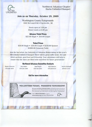
Ducks Unlimited Banquet October 29, 2009, in Fayetteville, Arkansas
Please click on images to move to Flickr site and use magnifying tool above photo to ENLARGE for easy reading.

Tuesday, October 13, 2009
Green Groups Guild meeting Thursday
From: Green Groups Guild (ggg@listserv.uark.edu) on behalf of ggg (ggg@UARK.EDU)
Sent: Tue 10/13/09 2:31 PM
To: GGG@LISTSERV.UARK.EDU
Meeting 10/15/09 7:00 p.m.
209 Thompson Ave. Three Sisters Bldg on Dickson above Fez Hookah Lounge.
Patrick Kunnecke
GGG President
ASLA Vice President
4th Year Landscape Architecture Student
479-544-1906
Sent: Tue 10/13/09 2:31 PM
To: GGG@LISTSERV.UARK.EDU
Meeting 10/15/09 7:00 p.m.
209 Thompson Ave. Three Sisters Bldg on Dickson above Fez Hookah Lounge.
Patrick Kunnecke
GGG President
ASLA Vice President
4th Year Landscape Architecture Student
479-544-1906
Tuesday, October 6, 2009
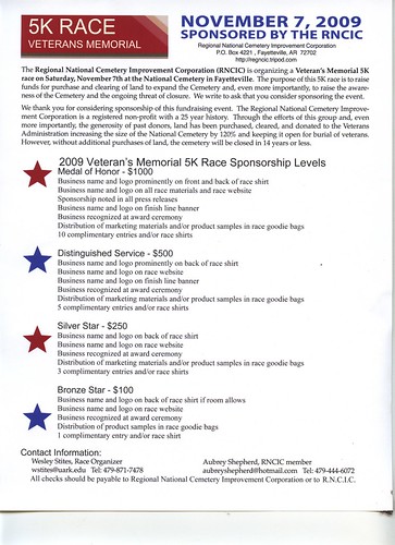
Runners and Sponsors sought for Nov. 7, 2009, 5K veterans' memorial race to benefit Fayetteville National Cemetery
Please click on image to move to Flickr site and ENLARGE for easy reading. The Regional National Cemetery Improvement Corporation meets at 10:30 a.m. Saturday October 10 and needs to add sponsor names to the file for the race T shirts and the brochures so that printing can begin. Already, Tyson Foods has donated at the Medal of Honor level and has challenged others to join them at the top of the list, thanks to the effort of RNCIC Secretary Peggy McClain.
Thursday, September 3, 2009
Karst map shows Red Oak Park as significant groundwater-recharging area
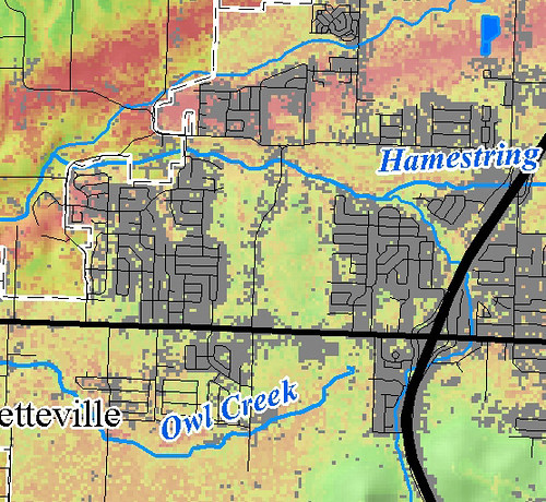
The portion of the Washington County karst map above is signficant and useful. But a thorough study of Northwest Arkansas' similar underground geology is desperately needed to prevent continued abuse of our natural heritage.


http://water.usgs.gov/ogw/karst/kigconference/wfl_ecologicalwetlands.htm
The Ecological Role of the Karst Wetlands of Southern Florida in Relation to System Restoration
By William F. Loftus1, Maria Cristina Bruno2, Kevin J. Cunningham3, Sue Perry2, and Joel C. Trexler4 1 U.S. Geological Survey, Biological Resources Division, Everglades National Park. Homestead, Florida 33034. Bill_Loftus@usgs.gov 2 South Florida Natural Resources Center, Everglades National Park. Homestead, Florida 33034. 3 U.S. Geological Survey, Water Resources Division, Miami Subdistrict, Miami, Florida 33178. 4 Florida International University, University Park, Miami, Florida 33199
Download PDF 2.87 MB
Adobe Acrobat Reader is required to view the report and can be downloaded for free
<--Return to Table of Contents
INTRODUCTION
With the recent funding of the Comprehensive Everglades Restoration Plan (CERP), the largest ecosystem restoration program ever attempted, there is a pressing need to be able to detect changes in natural habitats as a result of restoration actions. Human activities, particularly the construction of canals and levees that can either drain or flood wetlands, have affected the natural variability of environmental conditions (Gunderson and Loftus 1993). CERP intends to restore natural hydropatterns to areas that have been damaged by water management. Baseline data on constituent aquatic communities and their ecology are needed before, during, and after the restoration activities commence.
Freshwater fishes and invertebrates are important ecosystem components in the Everglades/Big Cypress system. They operate at several trophic levels in the wetlands, from primary consumers of plant material and detritus to carnivores and scavengers. Factors that influence fish and invertebrate numbers, biomass, and composition therefore affect energy flow through the wetlands. The ecology and life histories of these animals are intimately tied to the hydrology of the wetlands, which is determined mainly by rainfall, but increasingly by water-management practices. Because of the hydrological changes wrought by drainage and impoundment, and the loss of spatial extent and functioning of former wetlands to development (Gunderson and Loftus 1993), there is little doubt that standing crops and overall numbers have declined. Changes to the original ecosystem have also altered the timing and the areas of prey availability to predators. Non-native fishes have colonized natural and disturbed habitats during the past three decades. Non-native fishes have affected native animals through predation, nest-site competition, and habitat disturbance (Loftus 1988) and may divert food-web energy into biomass unavailable to top-level predators.
Aquatic animals in southern Florida wetlands have a variety of ways to cope with environmental variability. These include movements to find refuge from drying habitats in winter and spring, and dispersal away from those refuges with the onset of the wet season (Kushlan 1974, Loftus and Kushlan 1987). This pattern of movements among habitats with fluctuating water depths is common to seasonal wetlands in the tropics (Lowe-McConnell 1987, Machado-Allison 1993). The major natural refuge habitat most-studied by scientists in southern Florida is the alligator hole (Craighead 1968, Kushlan 1974, Nelson and Loftus 1996). Canals and ditches offer a relatively recent but spatially extensive form of artificial refuge for aquatic animals on the landscape (Loftus and Kushlan 1987). In this study, we are studying the function of other types of aquatic refuges in the Everglades.
The Rocky Glades, or Rockland, habitat is a karstic wetland unique to Everglades National Park (ENP) in southern Florida (Figure 1), although similar habitats exist elsewhere in Yucatan, Cuba, and the Bahamas. Approximately half of the original area of this habitat occurs outside of ENP where agricultural and urban development has forever altered its geological structure and ecological function. This region is a high priority for restoration in CERP because it is the largest remnant, short-hydroperiod wetland in the eastern Everglades. That habitat has been disproportionately lost from the ecosystem. Unfortunately, the habitat remaining in ENP has been degraded by water management (Loftus et al. 1992).
Figure 1. Locations of the study sites within the Rocky Glades and Atlantic Coastal Ridge in southern Florida. The numbers indicate the drift-fence arrays on the main park road, and the stars on the coastal ridge are the well sites with Miami cave crayfish.
The highly eroded karst structure of the Rocky Glades appears to be responsible for the persistence of aquatic-animal communities by offering dry-season refuge in thousands of solution holes of varying depths, (Loftus et al. 1992). Their work was the first to indicate a tight relationship among the biological, geological, and hydrologic components of this region. Loftus et al. (1992) also found evidence that aquatic animals disperse, feed, and reproduce on the wetland surface during the short flooding period, then retreat below ground for periods of months to years. They also reported that several introduced species, particularly the pike killifish (Belonesox belizanus), walking catfish (Clarias batrachus), Mayan cichlid (Cichlasoma urophthalmus), and black acara (Cichlasoma bimaculatum) were common in the Rocky Glades (Loftus et al. 1992). Unfortunately, their study was interrupted by Hurricane Andrew and not continued.
In this paper, we report the rationale and results of the first year of a new study in which the primary goal is to define the interactions of the aquatic-animal community with the geologic structure and hydrologic conditions of the Rocky Glades. We are addressing questions that have arisen from past work there. How do composition, size-structure, and recruitment of aquatic animals change during the flooding period? Are the dispersal patterns of animals related to water flow? Are the animals dispersing from the main sloughs to recolonize the Rocky Glades, or is the Rocky Glades a source of animal colonists for the sloughs? Do roadways act as barriers to movement? The objectives of this study segment are:
• Collect baseline ecological data on the epigean aquatic communities in the karst landscape of the Rocky Glades.
•
•
• Quantify the direction and degree of dispersal by fishes and invertebrates during the wet season.
•
•
• Document the seasonal changes in species composition, size structure, and reproductive patterns of animals on the wetland surface.
•
•
• Survey the topography of representative areas of the Rocky Glades, particularly around the sampling sites, to provide depth-distribution data for the simulation model of the region.
•
•
• Develop a visual survey method for sampling fish communities in open, rugged terrain to follow community dynamics in the Rocky Glades in the wet season.
•
•
• Identify the extent of near-surface voids.
The Atlantic Coastal Ridge is another area affected by urbanization and changing hydrologic management (Figure 1). Aquatic habitats, such as the transverse glades that cut through the Ridge, have been replaced by canals and will not be restored. Ground-water habitats and animal communities may have been less affected. As in karst areas elsewhere, deeper geological formations (>5 m) beneath the Rocky Glades and the Atlantic Coastal Ridge have voids of various dimensions known to house truly subterranean aquatic species (Radice and Loftus 1995, Bruno et al., this volume). These include the Miami Cave Crayfish (Procambarus milleri), known only from a few wells in southern Florida (Hobbs 1971). The composition, distribution, and abundance of other hypogean animals are poorly known. Ground-water withdrawal and saltwater intrusion (Leach et al. 1972), limestone mining, and pollution may threaten these communities before they have been fully catalogued. Elsewhere in the world, such communities are known to be very sensitive to changes in their delicately balanced physical environment. The second goal of this project is to identify the composition, distribution by depth and space, and ecological relations of this subterranean fauna. The objectives of the second study element include:
• Develop effective traps to capture invertebrates and possibly fishes from subterranean habitats.
•
•
• Inventory hypogean communities and relate the composition and distribution to environmental factors.
•
•
• Collect life-history data for the Miami cave crayfish from a large captive population.
METHODS
This first project year has been a pilot study to test designs and methods. The study is divided into two elements with several components each.
Element 1: In the Rocky Glades, we selected four sites along the ENP main road (Figure 1) to test the use of drift-fence arrays to describe directional animal dispersal and community successional patterns in the wet season. The four X-shaped arrays had 12-m wings made of black plastic ground cloth (Figure 2) to direct animals into one of 3 traps that faced east, north, and west, based on the direction that they were moving (Figure 2). The road shoulder formed a barrier to the south of each array. The 3-mm mesh minnow traps were fished overnight for 24 h to provide data on fish relative abundances, movements, and catch per unit effort (CPUE).
http://water.usgs.gov/ogw/karst/kigconference/wfl_ecologicalwetlands.htm
Tuesday, August 25, 2009
Leased riparian areas to be restored to protect Illinois watershed
The Morning News
Local News for Northwest Arkansas
State, Federal Government To Lease Land To Protect River
By Doug Thompson
THE MORNING NEWS
ROGERS — More than 20 square miles of land along the Illinois River and its tributaries will be planted with trees, native grasses and other plants under a project launched Tuesday.
The program's goal is to stop 10,000 tons a year of pollutants and sediment from getting into the river, state and federal organizers said. The 15,000-acre, $30 million program will be the largest of its type in Arkansas, by far, said Randy Young, director of the state Natural Resources Commission.
"Northwest Arkansas, growing economic gem that it is, is also cognizant of the need to protect our natural resources," said Gov. Mike Beebe. The governor publicly thanked the Walton Family Foundation for a $1 million contribution to the project.
The Conservation Reserve Enhancement Program is voluntary, organizers said. Landowners can apply to sign 15-year contracts with the U.S. Department of Agriculture for their plots of land along the river and streams.
Cropland and poor quality pastures are sought under the $30 million project. Those lands will be planted with native plants to stem erosion and provide food and shelter to wildlife, organizers said. The contracts will pay an estimated average of $85 per acre annually with a starting bonus amounting to as much as $350 an acre.
"I'm very interested. I'd sign up today if the forms were here," said dairy farmer Bill Haak of Gentry. "This is very farmer friendly and, if you look at the details, you can see that the people who wrote this up have the insight into what will make it work."
"I have grandkids," Haak said when asked why he was interested. "You need another reason than that? Well, this is a chance for farmers to step up to the plate and help preserve water quality."
Oklahoma Attorney General Drew Edmondson is suing Arkansas poultry companies in federal court over pollution in the Illinois River. The case is scheduled for trial Sept. 21.
"We hope this project will help prevent pollution from reaching the waters of the Illinois and its tributaries and support these types of efforts in both states," Edmondson said in a prepared statement about Tuesday's announcement.
The conservation program in Arkansas will match up with a similar one in Oklahoma. The two programs will cover the entire Illinois River watershed, Young said.
Of the $30 million, $24 million will come from a federal appropriation sought and obtained largely through the efforts of 3rd District Rep. John Boozman, R-Rogers, organizers said. Most of the rest will come from a $1.5 million appropriation from the state and in-kind services provided by the state, such as planning for each plot's project by the state Game and Fish Department and other agencies and water quality monitoring by the state Department of Environmental Quality.
Contact Information
Watershed Leases
Those interested in the project can call the Washington County office of the federal Farm Service Agency, 479-521-4520, or the Benton County office, 479-273-2622. Information is also available at www.fsa.usda.gov.
Saturday, July 18, 2009
Fayetteville food drive and Washington County "stop the quarry" efforts touted on square on Saturday July 18, 2009
Please click on images to ENLARGE view of details. The finger points to the area where the red-dirt pit that owners want to convert to a limestone mine sits on the edge of Fayetteville. It is up to the Washington County Quorum Court to see that the proposal is not allowed. Residents of Fayetteville and the rest of Washington County must let their justices of the peace know their feelings about this project or it could become an even uglier disaster than shown on the poster. And the limestone pit is estimated to take 75 years to deplete!


Subscribe to:
Posts (Atom)