 Please click on image to ENLARGE view of land dredging at Fayetteville National Cemetery on April 23, 2010.
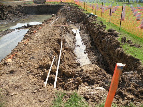
Saturday, April 24, 2010
Green infrastructure still being destroyed: Boozeman, Lincoln and Pryor all promised in 2009 to cooperate to get federal money appropriated to buy sale-barn property; instead, their failure to act has resulted in wet-prairie land north and west of the National Cemetery being dredged and filled for burial sites
Fayetteville National Cemetery photo set. Scroll to bottom of set for more of today's photos This didn't have to happen. Could it be related to the fact that none of the three is a U.S. military veteran? Or did they have more important people's votes in mind? The percentage of veterans who vote is pretty high. The right to vote has always been a reason for many to agree to fight to protect our Democratic form of government. Please click on image to ENLARGE view of land dredging at Fayetteville National Cemetery on April 23, 2010.
Please click on image to ENLARGE view of land dredging at Fayetteville National Cemetery on April 23, 2010.
Friday, April 16, 2010
Earth Day Festival began Friday night with Caring for Creation at Mount Sequoyah; Earth Day at World Peace Wetland Prairie from 1 to 5 p.m. Sunday, April 18, 2010, offers eduction and fun for all ages
Please click on image to ENLARGE for closer view of sample photos from WPWP.

PLEASE double-click the image to ENLARGE view and ENLARGE further with your computer's tools to read small type. For more about World Peace Wetland Prairie please see www.flickr.com/photos/7295307@N02/collections/ www.flickr.com/photos/7295307@N02/collections/
PLEASE double-click the image to ENLARGE view and ENLARGE further with your computer's tools to read small type.

MANY REASONS TO PROTECT LAND SUCH AS WORLD PEACE WETLAND AND PINNACLE PRAIRIE FOREVER:
World Peace Wetland Prairie is the riparian zone of a small stream that historically was fed by seep springs and rainwater from three directions when the first westward immigrants settled Fayetteville, Arkansas. World Peace Wetland Prairie has the deepest layer of dark, rich soil in its subwatershed because leaves and other vegetative matter accumulated as the flowing water slowed and soaked into the absorbent soil and enriched that soil. Pinnacle Foods Inc.'s mounded wet prairie to the west is the main source of clean water flowing to World Peace Wetland Prairie at this time. Before the railroad was built, water flowed off Rochier Hill to the northwest and from the prairie and savannah to the north of WPWP that has been replaced by fill dirt and paving for apartments. Water from the east and north slopes of the high land where Pinnacle Foods Inc. now sits flowed to WPWP along with all the water from the high ground near 15th Street, which moved north to WPWP before flowing east to the Town Branch of the West Fork of the White River. Such remnants of prairie help keep the water where it falls and recharge the groundwater. Like the many similar remnants of such prairie in our diverse geographical area, WPWP and Pinnacle Prairie are the surface manifestation of a significant bedrock fault. Such sunken wetland is a characteristic feature that appears above geological faults worldwide. The Karst map of Washington County Arkansas shows the WPWP watershed in red, meaning that it is a critical groundwater recharge area. Preserving such depressional wetland in our city is the least expensive way to reduce downstream flooding and siltation of our water supply. Hundreds of native plants grow. Many birds and other wildlife prosper on healthy wetland vegetation. And prairie vegetation sequesters carbon dioxide and cleans the ground water.


KEEP the WATER where it FALLS!
Monday, March 22, 2010
Ask Congress to restore Clean Water Act now
Please double-click "view as webpage" link near top right to see full post.
I would like to express grave concern over the loss of protection for many of our small streams that provide clean drinking water for 117 million Americans in communities across the country. Supreme Court decisions in the Rapanos and Carabell cases have made it confusing and burdensome for the U.S. Environmental Protection Agency (EPA) and U.S. Army Corps of Engineers to protect small streams and wetlands under the Clean Water Act. As a result, enforcement actions against polluters have declined sharply the EPA estimates that over 1,000 cases have been shelved or dropped altogether. More recently it has become clear that some polluters are using the decisions as a justification to avoid any permitting and reporting requirements for discharging pollutants into our waters. For the Clean Water Act to fulfill its goal of restoring the chemical, physical, and biological integrity of the nation's waters, all waters must receive protection corresponding with Congress' original intent when passing this landmark law. Upstream waters must be protected from pollution and destruction if we expect downstream waters to be fit for swimming, drinking, and fish and wildlife, and downstream communities to be safe from flooding. I urge you to act in the interest of preserving clean water for healthy communities and wildlife. Please support introduction and passage of the Clean Water Restoration Act, which would clarify the definition of waters to eliminate uncertainty and ensure clean water in accordance with the goals of the Clean Water Act. Thank you for your consideration.
 | ||||||||
 To contact American Rivers, email us at outreach@AmericanRivers.org. To update your profile or change your preferences click here. To unsubscribe click here. To contact American Rivers, email us at outreach@AmericanRivers.org. To update your profile or change your preferences click here. To unsubscribe click here. American Rivers ©2010 | ||||||||

 Katherine Baer Senior Director, Clean Water Program
Monday, February 22, 2010
Ward Four meeting at 7 p.m. today, after the Planning Commission meets
PUBLIC MEETINGS FOR THE WEEK OF FEBRUARY 22, 2010 (* Meetings scheduled to be televised by the Government Channel are indicated with an asterisk) Monday -- February 22 7:00 PM Ward 4 Meeting * Room 111 Discussion topics include traffic calming on Cleveland Street. All Wards welcome! |
Tuesday, February 9, 2010
Photo montage of World Peace Wetland Prairie
Please click on image to ENLARGE and navigate up and down, right and left, to see whole montage.
 Montage by Lauren D. Hawkins with photos by Aubrey James Shepherd

Saturday, February 6, 2010
OMNI Center for Peace, Justice and Ecology invites all to open house from 3 to 6 p.m. today
View Larger Map OMNI Center for Peace Justice and Ecology opens new house to all TODAY! Office Phone: (479)935-4422 omni.center.for.pje@gmail.com “OMNI Center for Peace, Justice & Ecology educates and empowers people to actively build a non-violent, sustainable and just world.” Saturday, February 2010 3:00—6:00 PM 3274 N. Lee Ave OMNI CENTER for PEACE, JUSTICE & ECOLOGY You are invited to celebrate the dedication of OMNI Center’s new building! Enjoy music, re- freshments, good fellowship, speakers, and tours! Learn more than 35 ways to be involved in OMNI. Help build a culture of peace in an earth restored, that includes everyone. Children Welcome! Handicap Access Refreshments Will Be Served! Open House!
Thursday, January 14, 2010
Times reports council allows Red Oak Park planning to continue
NWAOnline.com
Red Oak Repair To Move Forward
PARK WILL RECEIVE RESTORATION
Thursday, January 14, 2010
FAYETTEVILLE — A washed out drainage ditch at Red Oak Park that has kept Fayetteville officials in hot water with neighbors will get a combination of pipes, “plunge pools” and natural restoration to repair eroding banks.
The repair comes after a series of talks with occasionally frustrated residents in the neighborhood who have said they wanted the flooding and erosion fixed. However, many urged an approach that didn’t entirely rely on piping and allowed the channel to handle the large flow coming through the narrow park since the development of subdivisions such as Bridgeport.
Carole Jones, a park planner with the Fayetteville Parks and Recreation Division, told the City Council on Tuesday staff had developed a $218,000 plan to deal with the park’s water woes.
“There were a lot of interested people, with different goals,” said Jones. “We’ve tried this concept so that it meets all of those goals as best we can,”
Roughly $56,000 of the cost will be covered by the Parks Department and the remaining balance will be paid for through the city’s drainage fund.
In earlier discussions about resolving the problems, costs of nearly $500,000 were cited.
The park over the years has largely been split in two by the drainage ditch that grew as nearby development caused more runoff.
Under the proposed plan, the water’s path in the park will see the addition of ponding areas designed to slow the water down, allowing it to drop its load of sediment before moving on in a more controlled manner.
“The plunge pools are intended to take the energy out of the water, and take the silt out, and let it go on to Hamestring Creek,” said Chris Brown, chief engineer for the city’s engineering division.
On the downstream side — the area beyond New Bridge Road — 42-inch pipes will be installed to aid with drainage during mild storms, Brown said.
The project design is expected to be complete by the end of the month, Jones said. However, it then gets turned over to the U.S. Army Corps of Engineers for review. The City Council gave verbal permission at the agenda session to proceed with the project, she added.
“We cannot determine how long the review process will take,” Jones said, but added construction will begin soon after the corps’ review and approval.
Subscribe to:
Posts (Atom)